
PinPointWxLite
DescriptionThis App is all about giving you all the weather forecast parameters you need for a complete 7 day forecast. No frills, No smiling sunshine...
DescriptionThis App is all about giving you all the weather forecast parameters you need for a complete 7 day forecast. No frills, No smiling sunshine...

* Display Buoy observations including Sea height and Spectral Wave Energy.* ideal to gage surfing conditions using the spectral wave energy to see how...

* Display river levels from any of the 8000+ gages in the United States USGS river database.* If a river forecast is available from the National Weath...

Display the time in a graphical manner. Month is displayed vertically up along the left side. Day of Month is displayed vertically up the middle. Day ...

Display RAOB upper air data in a SkewT, Tephigram, or Stuve chart. Zoom the scale to see detail about inversion strength and height.Collect data for c...

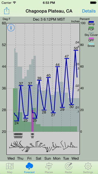
Display the weather forecast in a graphical manner for locations anywhere in the 50 United States, Puerto Rico, and Guam. No ads, ever. Just a 7 day w...
This App is all about giving you all the weather forecast parameters you need for a complete 7 day forecast. No frills, No ads, No smiling sunshine or...