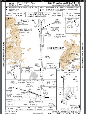
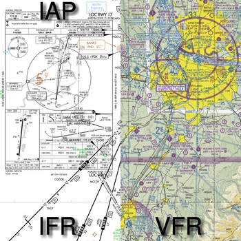
Still works on all iPad models! (including iPad1) Fastest in flight usage of all iPad EFB's- simply double tap on ANY airports to bring up A/FD and approach plates for that airport. Charts have track up and a detailed flight info strip is provided.SkyCharts does not *yet* support:* Charts outside of USA.* TFR and radar.For answers to many common questions please view the FAQ: http://www.skycharts.net/faq.htmlFor more information, please see the webpage athttp://www.skycharts.netFull description:Moving map with current IFR/VFR/TAC/FLY/HIFR/HELI/GCW/GOM/WAL aviation charts. DOUBLE TAP on map to view A/FD and approach plate. Map has VFR/IFR/LIFR color-coded METARs, with orange TAFs. SUA airspace information is also available.No service? No problem! Download charts and plates for offline usage. Flight plan and navigate using the ICAO airport/navaid database, or manually enter lat/longitude way points.Features:* Fast zoom/scroll of included charts using standard gestures.* Fast download of charts for offline usage. Charts are selected on a region basis, 7 for CONUS and 2 for Alaska. The ENTIRE CONUS only take about 1hr to download! Downloading all takes about 5GB of disk.* Flight planning with fuel and distance. Example: KUAO RAWER UBG MCCOY KSLE* Automatic waypoint sequencing* Navigation computes GS, TRK, DTK, DIS & ETE to current waypoint. * METAR/TAF color coded dots according to ADDS: http://www.skycharts.net/?page_id=421* Double tap on airport to select A/FD and TPPs/IAPs to view.* Call ASOS/AWOS/ATIS once an airport has been selected.* Huge built-in navigation database, with all 20,000 airports, 45,000 FAA IFR/VFR naviation fixes and 2,100 FAA VOR/ADF fixes.* XPlane flight simulator tracker. Follow the directions here: http://www.skycharts.net/?page_id=228* Location tracker. Enable the 'BreadCrumbs' setting in the system settings and your friends can check your current location. More details here http://www.skycharts.net/?page_id=365* See current chart cycle and expiration date. * Map in portrait or landscape mode* Toggle track up or north up. If you always use north up please set change the preference for SkyCharts for even faster viewing.* Airplane shows direction of flight when north up is selected.* Settings: http://scripts.skycharts.net/help3.2/settings.html VERY, VERY IMPORTANT, PLEASE READ!!!**BEFORE** trying to use SkyCharts offline, please download the region you will be using by pressing the 'i' button. This will download and save (cache) the charts and approach plates.For fast response to all questions, comments or suggestions, please email support@skycharts.netI personally respond to *all* queries usually within the same day. Thank you!


免費玩SkyChartsPro APP玩免費
免費玩SkyChartsPro App
SkyChartsPro APP LOGO
SkyChartsPro APP QRCode
| 熱門國家 | 系統支援 | 版本 | 費用 | APP評分 | 上架日期 | 更新日期 |
|---|---|---|---|---|---|---|
| 未知 | iOS App Store | 3.8 App下載 | 免費 | 2010-04-01 | 2015-06-03 | |
| 美國 (U.S.A) | iOS App Store | 3.4 App下載 | 免費 | 2014-04-14 | 2014-09-19 |