It’s quite cool—and really hot! weatherTAP zoom pushes personalized, current weather to the max with detailed storm tracking capability not available on any other app. Follow tornadoes and super cells with pinpoint precision using animated, interactive, real-time radar that is seamlessly integrated and scalable on friendly, familiar maps.
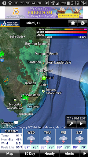
weatherTAP zoom keeps you on top of what the nasty weather’s doing, when it’s going to hit, and where. Using state-of-the-art radar technology, the most current NEXRAD Level 3 images are available on demand with hi-res clarity.
Powerful features prepare you before severe weather strikes. And knowing ahead of time about dangerous conditions helps you protect property and save lives. The app is accurate and reliable. Best of all, it’s fast, easy and free.
weatherTAP zoom’s storm tracks show the current location and path of each storm cell. Expected locations are continuously plotted at 15, 30, 45 and 60 minutes. You can watch trends by animating the last 12 images. Individual storm details include—

• Storm cell identity
• Tornadic vortex signature
• Mesocyclone strength
• Probability of hail and severe hail

• Maximum hail size
• Vertically integrated liquid
• Reflectivity in dBZ
• Height of the maximum dBZ
• Echo tops (height of the storm cell)

Severe weather warnings from the National Weather Service include tornados (red polygon), severe thunderstorms (yellow polygon) and flash floods (green polygon). Time-stamped precipitation images (base reflectivity, Level 3) can be animated.
View the maps in standard, satellite or hybrid mode. Just tap and hold to get current conditions and the five-day forecast for any U.S. location. Zoom, pan and scroll. Store your favorite locations for quick navigation. View your current location automatically on the map in relation to the weather around you.
The high-end features on weatherTAP zoom use data from all of the 156 NEXRAD radar sites throughout the USA, including Alaska, Hawaii, Guam and Puerto Rico. Use weatherTAP zoom as your secret weapon to stay ahead of Mother Nature’s fury!

The app is a service of weatherTAP.com, The Fastest Weather on the Web, twice designated “Best of the Web” by Forbes Magazine. For more information, visit www.weathertap.com.

免費玩weatherTAP zoom APP玩免費
免費玩weatherTAP zoom App
weatherTAP zoom APP LOGO

weatherTAP zoom APP QRCode
| 熱門國家 | 系統支援 | 版本 | 費用 | APP評分 | 上架日期 | 更新日期 |
|---|---|---|---|---|---|---|
| 美國 (U.S.A) | iOS App Store | 2.2.0 App下載 | 免費 | 2013-09-18 | 2014-09-19 |