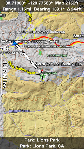
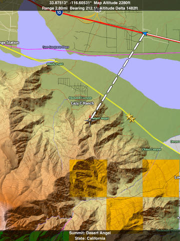
A 3D topo map of the Western USA. The vector map data is contained within the app so no internet connection is needed and there is nothing else to download. Use it in a car, a boat, a plane or while hiking. It is like having more than a third of the country in your pocket.Scroll like a map or fly like a flight simulator. Touch and hold anywhere on the map for two seconds to switch to virtual joystick controls and then fly around the terrain. Prefer a 2D map? Use the standard two finger vertical swipe gesture to tilt the map until you are looking straight down. This is the future of 3D mapping.Scenic Map is simply the best 3D topo map available for a mobile device. On the new iPad’s retina display you will see incredible detail while scrolling, rotating and zooming perfectly smoothly. You will see every road even if you scroll out to the altitude of a satellite. As you zoom in, you will see every small bump and hollow of the Earth and features as small as ten meters. Unlike old fashioned topo maps, Scenic Map’s roads and trails are up to date thanks to OpenStreetMap.org. It contains polygons for urban areas, shopping malls and an ever growing number of buildings, The best lake, pond, stream and rivers from the USGS are also included.Tap the GPS center button to begin tracking your location. As you move, you will generate a track file. Tracks can be replayed with video like controls to speed up, slow down, pause, restart or skip to the end. You can display an existing track while recording another if you want to retrace your route. Tracks can be received from or sent to other apps in GPX format.Scenic Map's combination hardware/software 3D map renderer is the first of its kind. It is so fast, it can display every road in a city the size of Los Angeles perfectly smooth animation. While most mapping apps hide smaller roads as you zoom out, Scenic Map can display every road at every zoom level. This is helpful when you are exploring remote areas because you can zoom out and see all the roads, not just the major highways.Never before have maps been this customizable. For example, you can turn on or off the roads. You can change the lighting direction or remove terrain shading entirely. You can display contour lines. You can even step through the months and watch the seasons change. There are five presets which let you quickly switch between map styles. Use metric or English units and choose one of four different coordinate displays including UTM.Want to learn more about a map feature? Tap the target icon and center the feature under the compass rose to display its name, type, urban area, state, elevation and coordinates. You will also see a bearing line back to your current GPS location or from your location to a selected waypoint. The status will display the bearing direction and distance along with the map and GPS elevation, the track length, and your current speed and direction of travel.Documentation, detailed coverage maps, installation guide and blog are available on ScenicMap.comScenic Map Western USA covers W109 to W162 degrees longitude. This includes the following states:Arizona, California, Hawaii, Idaho, Nevada, Oregon, Utah, WashingtonWestern parts of Colorado, Montana, New Mexico, Wyoming.Map data © OpenStreetMap and contributors under the Open Database License Scenic Map supports GPS tracking while the app is in the background.Caution: Continued use of GPS running in the background can dramatically decrease battery life.


免費玩Scenic Map Western USA APP玩免費
免費玩Scenic Map Western USA App
Scenic Map Western USA APP LOGO

Scenic Map Western USA APP QRCode
| 熱門國家 | 系統支援 | 版本 | 費用 | APP評分 | 上架日期 | 更新日期 |
|---|---|---|---|---|---|---|
| 未知 | iOS App Store | 1.6.1 App下載 | $9.99 | 2010-04-01 | 2015-06-03 | |
| 美國 (U.S.A) | iOS App Store | 1.6.1 App下載 | $9.99 | 2014-06-12 | 2014-09-19 | |
| 中國 China | iOS App Store | 1.6.1 App下載 | ¥68.00 | 2014-06-12 | 2014-10-03 |