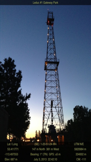
NAV Photo is a multi-functional App that combines camera, compass, GPS positioning, text editor and the timer. NAV Photo is created by the same company who created LSD NAV PRO which won the Association of Canada Lands Surveyors 2012 David Thompson Award for Innovation in Geomatics. NAV Photo stamps real time position, altitude, direction of camera, and Legal Township information on to the iPad/iPhone's camera image. The geo-tagged image can then be viewed on the Apple Photos app or emailed using the system tools.NAV Photo is a great tool for oil and gas industry applications where everything is based on the Legal Township system. It is a tool for surveyors, land agents, field consultants, geologists, engineers, hunters and farmers. It has many user selectable options for the position display. The most distinguishing and useful feature is that it displays the Legal Township information. It shows LSD-Sec-Twp-Rge-M (Legal Subdivision, Section, Township, Range, and Meridian) and offset distances from its Quarter Section boundaries. With the timer control, it is also a basic video logging and documentation tool.If you have to deal with the township system then you will appreciate NAV Photo.If you are confused by UTM and geographic outputs then you will love this App.The cellular option for the iPad is required for getting the location information.


免費玩Nav Photo APP玩免費
免費玩Nav Photo App
Nav Photo APP LOGO

Nav Photo APP QRCode
| 熱門國家 | 系統支援 | 版本 | 費用 | APP評分 | 上架日期 | 更新日期 |
|---|---|---|---|---|---|---|
| 未知 | iOS App Store | 2.9 App下載 | $34.99 | 2013-06-25 | 2015-06-03 |