Guthook's Guide to the Appalachian Trail is a detailed, map-based smartphone guide for your hike on the Appalachian Trail or the Long Trail. Part 8 covers the 172.2 mile portion of the AT through most of New Hampshire and a few miles into Maine: from Mile 1742 (Hanover, New Hampshire) to Mile 1914.2 (Maine Hwy 26, Grafton Notch). It maps and lists 268 important hiker waypoints on this portion of the AT such as water sources, shelters, tenting sites, road crossings, resupply locations, and may others.
NO PHONE OR INTERNET SERVICE IS REQUIRED to use Guthook's Guides after the initial setup. Guthook's Guides use a combination of your smartphone's GPS, downloaded topo maps, and the Google Maps interface to accurately locate your position on the trail. Your phone's GPS pinpoints your location on the downloaded topo maps.
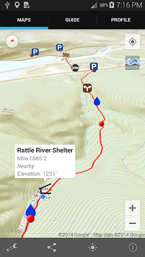
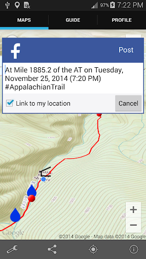
A bright red line indicates the location of the main trail on the map. Side spurs to water sources or other points of interest are indicated in blue. Waypoints of interest to the hiker are plotted on the map. There are also markers on the map every mile or kilometer of the trail track.
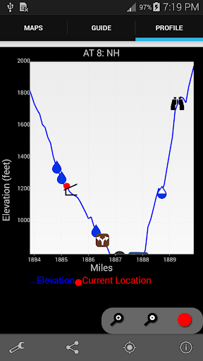
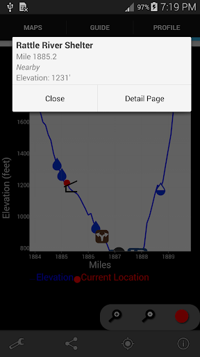
The elevation profile shows trail distance vs elevation and plots your current location on the trail. Each waypoint is plotted on the profile. Each waypoints is clickable, opening to the waypoint's detail page.
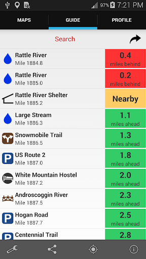
The guidebook lists every waypoint in order by distance along the trail and how far away you are from each waypoint.
Send your current location to friends and family via text message, e-mail, facebook or twitter.
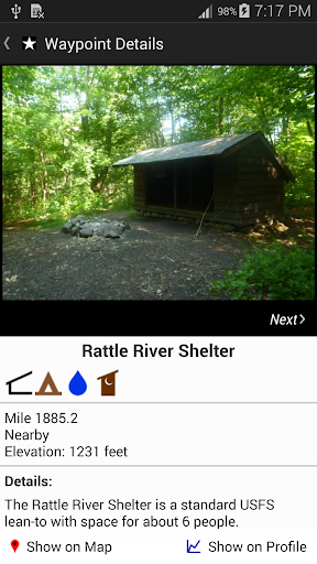
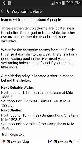
Each waypoint includes a detail page, providing further details about that particular waypoint. Details include the waypoint's mileage point and elevation, photographs of the waypoint, distance northbound and southbound to the next water source, a Trail Register where you may post comments and read other users' comments, and other details that will help you during your hike, and help you plan your hike.
The types of waypoints include:
-->Water sources (including the reliability of each water source)
-->Shelters/Lodges
-->Tenting sites/camping sites
-->Trail junctions
-->Parking areas along the trail
-->Picnic areas, campgrounds, ranger stations
-->Roads, railroad tracks, power lines
-->Natural landmarks (e.g. mountain peaks, lakes, bogs)
-->Privies/restrooms
-->Scenic Views
-->Towns on the trail
About the Appalachian Trail: The Appalachian Trail, or AT, is one of the United States' most treasured national trails. The 2,181-mile trail stretches from Springer Mountain in Georgia to Mount Katahdin in Maine. Along the way it passes through 14 states, including Georgia, North Carolina, Tennessee, Virginia, West Virginia, Maryland, Pennsylvania, New Jersey, New York, Connecticut, Massachusetts, Vermont, New Hampshire, and Maine. Much of the Long Trail overlaps the AT through the State of Vermont. Many hikers complete the entire trail in one season ("thru-hikers"), and countless others enjoy hiking anywhere from a few miles to hundreds of miles each year.
Also available:
Guthook's Guide to the Pacific Crest Trail
Guthook's Guide to the Continental Divide Trail
Guthook's Guide to the John Muir Trail
Guthook's Guide to the Tahoe Rim Trail
Colorado Trail Hiker
Mt. Whitney Guide
Vermont's Long Trail Hiker
Ghost Ranch Guide
免費玩Guthook's AT 8: New Hampshire APP玩免費
免費玩Guthook's AT 8: New Hampshire App
Guthook's AT 8: New Hampshire APP LOGO
Guthook's AT 8: New Hampshire APP QRCode
| 熱門國家 | 系統支援 | 版本 | 費用 | APP評分 | 上架日期 | 更新日期 |
|---|---|---|---|---|---|---|
| 未知 | Android Google Play | 3.1.0 App下載 | USD$8.99 | 1970-01-01 | 2015-04-25 |