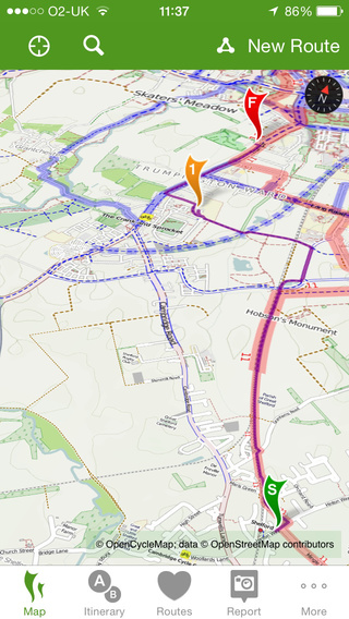
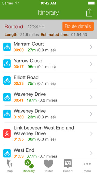
UK-wide cycle journey planner CycleStreets on your mobile device! Cycle journey planner for cyclists, by cyclists."Great implementation of sat-nav. Very clear and easy to use. Hasn't crashed yet." - Benjamin Frost"I've been using this as a satnav round London and the routes are superb - better than all the other planners." - borissimoPlan routes from A to B anywhere in the UK, with a choice of four routing modes to suit a range of cyclists from beginner to regular commuter. And the Photomap lets you submit photos of infrastructure problems or good practice around the UK.PLAN CYCLE ROUTES FROM A TO B (TO C, D, ..)Select a start and finish point by clicking on the map, by searching for names/places/postcodes, or by using your current location, and click to obtain the route.CHOICE OF FOUR ROUTING MODESThe app produces routes that will suit most cyclists. It can optionally can find faster or quieter routes for different types of rider. Routes are fetched from the CycleStreets website. You can switch the route type after planning it, and can save and rename and organise routes.HILLS? NO PROBLEM!The journey planner knows about hills, and finds routes that take advantage of the descents and avoids the ascents where possible. It balances these against the available road types. The route can be displayed on a map with contours using the OpenCycleMap option.STAGE-BY-STAGE ITINERARYAs well as the main map view, planned routes are loaded into an itinerary view, so you can follow each part of the journey. The street name, time and length are all shown, as is a detailed map for each individual stage of the journey. Routes are saved so you can also follow them again later.PHOTOMAPThe Photomap is a cycling advocacy tool used by campaign groups around the country. Use it to browse examples of problems or good practice, and add your own pictures. Need more cycle parking in your favourite spot in town? Sign in with a free account and add a photo of it to the Photomap.OPENSTREETMAPRouting makes use of OpenStreetMap data, the brilliant 'geo-wiki' to which you can contribute. Note that, at present, some areas of the country have better coverage than others. Streets and paths of all kinds, including Sustrans routes and Local Authority network, are included. Routing quality is being developed all the time, with new types of cycling and street data being added and interpreted by the route planner.Thanks to Neil Edwards for his hard work on this release.


免費玩CycleStreets: UK cycle journey planner and photomap APP玩免費
免費玩CycleStreets: UK cycle journey planner and photomap App
CycleStreets: UK cycle journey planner and photomap APP LOGO

CycleStreets: UK cycle journey planner and photomap APP QRCode
| 熱門國家 | 系統支援 | 版本 | 費用 | APP評分 | 上架日期 | 更新日期 |
|---|---|---|---|---|---|---|
| 未知 | iOS App Store | 3.0.1 App下載 | 免費 | 2010-09-21 | 2015-06-03 |